CANADA
Canada Political Divisions
A map of Canada showing boundaries, capitals, selected place names, selected drainage and names, the Arctic Circle and adjacent foreign areas.
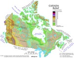
Relief
A relief map of Canada showing elevation by hypsometric tints,(a gradation of different colours). Major lakes are also shown. Elevation ranges are included in the map legend.
Standard Time Zones
A map showing Canada's six time zones as legislated and as observed; also gives internationally accepted names and designators.
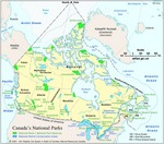
National Parks
A map showing the locations, extents and names of National Parks and National Marine Conservation Areas in Canada.
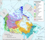
Drainage Basins
This map shows the five ocean drainage areas in Canada, the major river basins, the internal drainage areas and the diverted drainage areas. A drainage basin, sometimes called a watershed, is an area where all surface water shares the same drainage outlet. Surface water consists of the tiny trickles of water flowing on the surface of the earth that develop into larger streams and eventually combine to form a river. The boundary of a watershed is called a drainage divide.
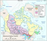
Historical Indian Treaties
This map shows Indian treaties that were negotiated between 1725 and 1930. Treaties are agreements between two or more nations that create mutually binding obligations. In Canada, Aboriginal peoples and various European and Canadian governments have concluded 68 major historical treaties over the last 275 years. These treaties cover most of Ontario, the Prairie Provinces, parts of Vancouver Island, Northwest Territories and Atlantic Canada.


